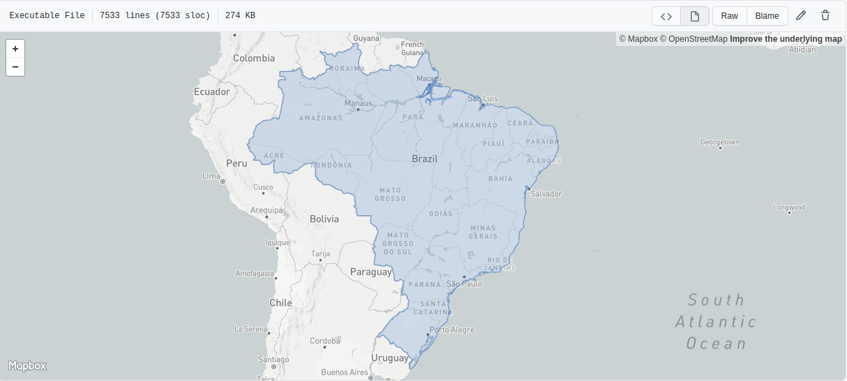
Your First Look
The CountryGeographical::class model provides detailed geographical data related to countries, including region classifications, time zones, and various identifiers (e.g., ISO, ITU, ICAO). This data allows for precise categorization and representation of countries across different global and regional systems.
GeoJSON Structure
GeoJSON (Geographic JSON) is a format for encoding geographic data structures using JSON. It is widely used in mapping applications and geospatial analysis to represent various geographical features like points, lines, and polygons.

GeoJSON
This GeoJSON object represents the full geographical boundaries of Brazil, utilizing the FeatureCollection structure and a MultiPolygon geometry type to handle the complexity of the country's borders, including islands and coastal regions. Below, we break down the key components relevant to developers working with geospatial data:
🔑 Key Components
FeatureCollection:
- The root object is a FeatureCollection, which is a standard GeoJSON structure that contains multiple Feature objects. In this case, it encapsulates Brazil’s geographic representation.
Feature:
- Each Feature represents a single geographic entity. Here, Brazil is represented as a Feature, with metadata included in the properties section. This modular design allows developers to easily manage multiple geographic objects within a single FeatureCollection.
Properties:
- The properties object holds non-spatial data about the feature. In this example, the ISO Alpha-2 country code
"br"is included as a property under"cca2". These properties can be extended to include additional metadata, such as population data or administrative classifications, depending on your use case.
- The properties object holds non-spatial data about the feature. In this example, the ISO Alpha-2 country code
Geometry:
- The geometry field defines the spatial shape of the feature. For Brazil, the geometry type is "MultiPolygon", which allows the representation of the country's complex boundaries, including multiple distinct areas like islands or disjointed regions. This makes it ideal for use in applications that require detailed boundary mapping or geospatial analysis.
GeoJSON Example
Brazil GeoJson Example
Click me to view the example
{
  "type": "FeatureCollection",
  "features": [
    {
      "type": "Feature",
      "properties": { "cca2": "br" },
      "geometry": {
        "type": "MultiPolygon",
        "coordinates": [
          [
            [
              [-48.55056, -27.82139],
              [-48.55667, -27.82278],
              [-48.563057, -27.82139],
              [-48.565285, -27.816669],
              [-48.566673, -27.81111],
              [-48.566673, -27.79889],
              [-48.56583, -27.79278],
              [-48.55056, -27.69611],
              [-48.53167, -27.646946],
              [-48.502785, -27.56167],
              [-48.50111, -27.556114],
              [-48.50111, -27.549168],
              [-48.503334, -27.544445],
              [-48.52167, -27.51833],
              [-48.527779, -27.491669],
              [-48.52361, -27.46639],
              [-48.51833, -27.43556],
              [-48.51723, -27.430836],
              [-48.43084, -27.39],
              [-48.42473, -27.388889],
              [-48.418335, -27.388889],
              [-48.414169, -27.39167],
              [-48.410835, -27.395557],
              [-48.37195, -27.44361],
              [-48.371117, -27.44972],
              [-48.40639, -27.59278],
              [-48.412506, -27.60111],
              [-48.44833, -27.63084],
              [-48.45889, -27.641945],
              [-48.49667, -27.71139],
              [-48.499725, -27.722504],
              [-48.500557, -27.728615],
              [-48.499725, -27.73473],
              [-48.498337, -27.74028],
              [-48.492226, -27.74861],
              [-48.485, -27.75611],
              [-48.479729, -27.765],
              [-48.479729, -27.77167],
              [-48.48222, -27.776669],
              [-48.48611, -27.78],
              [-48.54056, -27.816669],
              [-48.55056, -27.82139]
            ]
          ],
          [
            [
              [-48.58112, -26.39167],
              [-48.58584, -26.425556],
              [-48.62611, -26.39333],
              [-48.70556, -26.31444],
              [-48.707779, -26.309723],
              [-48.70473, -26.305557],
              [-48.55, -26.16972],
              [-48.54472, -26.167778],
              [-48.537781, -26.16722],
              [-48.52639, -26.17056],
              [-48.51723, -26.17611],
              [-48.51445, -26.18028],
              [-48.485, -26.22889],
              [-48.485, -26.234169],
              [-48.49028, -26.243057],
              [-48.517784, -26.280003],
              [-48.52723, -26.29222],
              [-48.531113, -26.29556],
              [-48.54028, -26.307781],
              [-48.54501, -26.317223],
              [-48.5789, -26.38667],
              [-48.58112, -26.39167]
            ]
          ],
          ...
        ]
      }
    }
  ]
}